

Térkép - Soroksári Botanikus Kert
Térkép
Térkép
Utolsó frissítés: 2023 április 26.
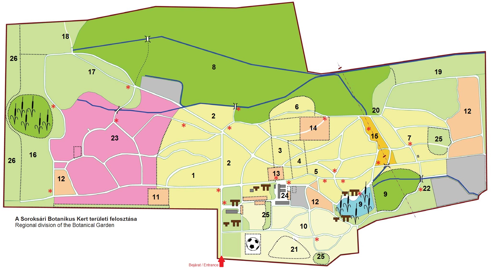
Élőhelyek:
1. Észak-Amerika növényei / Plants of North America
2. Kelet-Ázsia növényei / Plants of East Asia
3. Közép-Ázsia, Kisázsia növényei / Plants of Central Asia and Asia Minor
4. Kaukázusi növények / Plants of the Caucasus
5. Kelet- Közép- és Dél-Európa növényei /Plants of Eastern, Central and Southern Europe
6. Szibériai növények / Plants of Siberia
7. A Kárpátok növényei / Plants of the Carpathians
8. Rezervátum / Reserve
9. Vizes élőhelyek / Wetlands
10. Homokpusztagyepek / Sand steppes
11. Magyarország vadrózsái / Wild roses of Hungary
12. Vad gyümölcsfajok / Wild fruit species
13. Borostyángyűjtemény / Ivy collection
14. Honos évelők / Native perennials
15. Középhegységek növényei / Plants of the Hungarian mountains
16. Karsztbokorerdő / Calcareous shrub woodland
17. Alföldi kocsányos tölgyes / Pedunculate oak woodland of the Great Hungarian Plain
18. Tatárjuharos tölgyes / Tartarian maple–oak woodland
19. Gyertyános–bükkös / Hornbeam–beech woodland
20. Nyíres / Birch woodland
21. Fehérnyáras borókás / White poplar–juniper association
22. Szikesek növényei / Plants of saline grasslands
23. Rendszertani gyűjtemények / Taxonomic collections
24. Mediterrán és szubtrópusi gyűjtemény / Mediterranean and subtropic collection
25. Akácos / Black locust plantation
26. Véderdő / Shelter-belt
Egyéb létesítmények:
![]() Sétaút / Walking path
Sétaút / Walking path
![]() Időszakosan járható sétaút / Temporary path
Időszakosan járható sétaút / Temporary path
![]() Bemutató egység határa / Border of demonstration unit
Bemutató egység határa / Border of demonstration unit
![]() Vízgyűjtő árok, híd / Drainage ditch, bridge
Vízgyűjtő árok, híd / Drainage ditch, bridge
![]() Villamos távvezeték / Electric power line
Villamos távvezeték / Electric power line
![]() Kerti pihenőhelyek / Garden relax places
Kerti pihenőhelyek / Garden relax places
![]() Ismertető táblák / Information tables
Ismertető táblák / Information tables